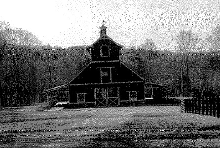
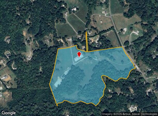
Property Record
400 Henson Way, Canton, GA 30115
NEARBY LISTINGS FOR SALE OR LEASE
Property Detail
400 Henson Way
Atlanta-Sandy Springs-Roswell, GA
Willow Rdg Woodall Llc Surv
003N06-00000-037-000-0000
LL 1150,1155; 3RD D PB 80/17
Agriculturalland
Cherokee
A
Georgia
13057C0260E
1
2025
49.84 AC
2025
Cherokee County
090603
Atlanta
1,300 SF
DEMOGRAPHICS near 400 Henson Way
1 Mile
3 Mile
5 Mile
2024 Total Population
1,014
14,023
56,222
2029 Population
1,152
16,032
64,310
Pop Growth 2024-2029
+ 13.61%
+ 14.33%
+ 14.39%
Average Age
41
40
40
2024 Total Households
339
4,699
18,894
HH Growth 2024-2029
+ 13.86%
+ 14.47%
+ 14.54%
Median Household Inc
$111,475
$117,530
$108,114
Avg Household Size
3.00
2.90
2.90
2024 Avg HH Vehicles
2.00
2.00
2.00
Median Home Value
$429,787
$419,473
$408,847
Median Year Built
2003
2002
2002
Nearby Places
- Restaurants
- Banks
- Shops
- Fitness
- Groceries
Nearby Properties
Address
Land Use
TOTAL SIZE
Lot Size
Zoning
Address
Land Use
TOTAL SIZE
Lot Size
Zoning
313,906 SF
28.96 AC
PD
Address
Land Use
TOTAL SIZE
Lot Size
Zoning
24,586 SF
PD
Address
Land Use
TOTAL SIZE
Lot Size
Zoning
178,576 SF
13.74 AC
GC
Address
Land Use
TOTAL SIZE
Lot Size
Zoning
191,105 SF
12.37 AC
PD
Address
Land Use
TOTAL SIZE
Lot Size
Zoning
151,121 SF
33.37 AC
GC
Address
Land Use
TOTAL SIZE
Lot Size
Zoning
133,843 SF
31.69 AC
AG
Address
Land Use
TOTAL SIZE
Lot Size
Zoning
139,274 SF
12.34 AC
PD
Address
Land Use
TOTAL SIZE
Lot Size
Zoning
58.97 AC
OI
Address
Land Use
TOTAL SIZE
Lot Size
Zoning
69,966 SF
22.62 AC
GC
Address
Land Use
TOTAL SIZE
Lot Size
Zoning
54.76 AC
PD
Address
Land Use
TOTAL SIZE
Lot Size
Zoning
86,913 SF
6.47 AC
PD
Address
Land Use
TOTAL SIZE
Lot Size
Zoning
30,996 SF
2.05 AC
PDR
Address
Land Use
TOTAL SIZE
Lot Size
Zoning
39,657 SF
149.32 AC
AG
Address
Land Use
TOTAL SIZE
Lot Size
Zoning
85,610 SF
9.76 AC
GC
Address
Land Use
TOTAL SIZE
Lot Size
Zoning
52,895 SF
4.02 AC
GC
Address
Land Use
TOTAL SIZE
Lot Size
Zoning
960 SF
78.30 AC
R-15
Address
Land Use
TOTAL SIZE
Lot Size
Zoning
13,966 SF
1.56 AC
GC
Address
Land Use
TOTAL SIZE
Lot Size
Zoning
8,856 SF
0.97 AC
NC
Address
Land Use
TOTAL SIZE
Lot Size
Zoning
20 AC
PD
Address
Land Use
TOTAL SIZE
Lot Size
Zoning
10,120 SF
1.25 AC
O-I
Address
Land Use
TOTAL SIZE
Lot Size
Zoning
1,462 SF
8.74 AC
NC
Address
Land Use
TOTAL SIZE
Lot Size
Zoning
22,729 SF
4.05 AC
AG
Address
Land Use
TOTAL SIZE
Lot Size
Zoning
6,042 SF
2.63 AC
GC
Address
Land Use
TOTAL SIZE
Lot Size
Zoning
134.91 AC
AG
Address
Land Use
TOTAL SIZE
Lot Size
Zoning
2,946 SF
8.72 AC
NC
Address
Land Use
TOTAL SIZE
Lot Size
Zoning
7,284 SF
62.19 AC
AG
Address
Land Use
TOTAL SIZE
Lot Size
Zoning
6,080 SF
9.91 AC
GC
Address
Land Use
TOTAL SIZE
Lot Size
Zoning
12,160 SF
3.85 AC
PD
Address
Land Use
TOTAL SIZE
Lot Size
Zoning
30,557 SF
9.88 AC
R-80
Address
Land Use
TOTAL SIZE
Lot Size
Zoning
21.56 AC
PD
The World's #1 Commercial Real Estate Marketplace
Connect with us
© 2025 CoStar Group
The information above has been obtained from sources believed reliable. While we do not doubt its accuracy we have not verified it and make no guarantee, warranty or representation about it. It is your responsibility to independently confirm its accuracy and completeness. Any projections, opinions, assumptions, or estimates used are for example only and do not represent the current or future performance of the property. The value of this transaction to you depends on tax and other factors which should be evaluated by your tax, financial, and legal advisors. You and your advisors should conduct a careful, independent investigation of the property to determine to your satisfaction the suitability of the property for your needs.